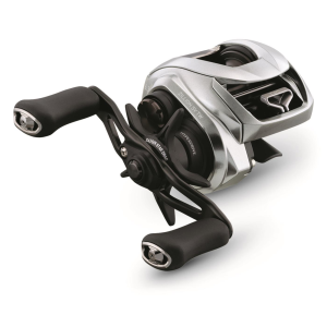
Buy Daiwa Zillion SV TW Low Profile Baitcasting Reel 7.1:1 Gear Ratio Right Hand Retrieve $349.99 Now!
Daiwa Zillion SV TW Low Profile Baitcasting Reel 7.1:1 Gear Ratio Right Hand Retrieve - $349.99
For the last 40 years, Daiwa has set the standard for high-quality, innovative reels Perfect for fishing reels | baitcasting.
For the last 40 years, Daiwa has set the standard for high-quality, innovative reels. And now they've done it again with the new and improved Zillion SV TV Baitcasting Reel. Lightweight, durable Reel features Daiwa's advanced Hyper Drive design that provides ultra-smooth retrievals and powerful winding performance. Plus, you'll love its SV Booster System that gives outrageously long casting distance with near-zero backlashes, even when using lightweight lures in windy conditions. Hyper Drive Digigear design for reduced gear noise and a smoother feel Hyper Double Support System for the reel's pinion gear means no flex and ultra-smooth retrievals Hyper Armed Housing with aluminum frame and sideplate for maximum rigidity Hyper Tough reinforced clutch mechanism for increased durability and performance TWS T-Wing System allows your line to exit freely from the spool with minimal line angle and minimal friction for improved casting distance SV Booster System for increased casting control Order today!
Buy Now for $349.99

